|
|
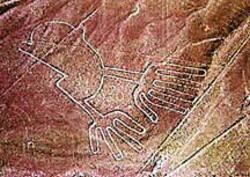
Nazca Lines
 The
Nazca Lines are gigantic geoglyphs
located in the Nazca Desert, a high arid plateau that stretches 53 miles
between the towns of Nazca and Palpa on the Pampas de Jumana in
Peru.
They were created by the Nazca culture between 200 BC and 600 AD. There
are hundreds of individual figures, ranging in complexity from simple
lines to stylized hummingbirds, spiders, monkeys, and lizards. The Nazca
lines cannot be recognized as coherent figures except from the air.
Since it is presumed the Nazca people could never have seen their work
from this vantage point, there has been much speculation on the builders'
abilities and motivations. The
Nazca Lines are gigantic geoglyphs
located in the Nazca Desert, a high arid plateau that stretches 53 miles
between the towns of Nazca and Palpa on the Pampas de Jumana in
Peru.
They were created by the Nazca culture between 200 BC and 600 AD. There
are hundreds of individual figures, ranging in complexity from simple
lines to stylized hummingbirds, spiders, monkeys, and lizards. The Nazca
lines cannot be recognized as coherent figures except from the air.
Since it is presumed the Nazca people could never have seen their work
from this vantage point, there has been much speculation on the builders'
abilities and motivations.
The conquistador chronicler Pedro de Cieza de Leon first mentioned some
of the figures in 1547. He described the few glyphs drawn on hillsides
whose shape can be seen without an aircraft.
The lines were first noticed in the modern era when airplanes began
flying over the Peruvian desert in the 1920s. In 1927, Toribio Mejia
Xespe, a Peruvian doctor and anthropologist was the first scientist to
show interest in what he called these "great Incan ceremonial artifacts".
The first systematic and scientific survey of the lines began in the
1930s under the direction of Paul Kosok and Maria Reiche. Reiche took
over the study in 1946 and until her death in 1998 lobbied to protect
and preserve the lines. She lobbied successfully to have the lines
declared a UNESCO World Heritage Site in 1995. Since then, improved
aerial and satellite photography as well as increased interest and study
of the glyphs and the surrounding desert has added to our knowledge of
the site as well as the people who built it. For instance Cahuachi, a
Nazca city overlooking some of the lines, was recently discovered in the
surrounding hillside. It was built nearly 2,000 years ago and
mysteriously abandoned 500 years later.
The lines were made by removing the iron oxide coated pebbles which
cover the surface of the Nazca desert. When the gravel is removed, they
contrast with the light-colored earth underneath. There are several
hundred simple lines and geometric patterns on the Nazca plateau, as
well as over seventy curvilinear animal, insect, and human figures. The
area encompassing the lines is nearly 200 square miles, and the largest
figures can be nearly 900 feet long. The lines persist due to the
extremely dry, windless, and constant climate of the Nazca region. The
Nazca desert is one of the driest on earth and maintains a temperature
around 25�C (77�F). The lack of wind in the desert has helped keep the
lines uncovered to the present day.
Nazca Lines Pictures
|
Nasca
Lines Tours
The coastal region
accounts for 10.6% of Peru's territory (52,639 square miles or
136,334 km2). It is a narrow strip 1hat is approximately 554
miles long (2,500 km), but only 12 to 62 miles wide (19 to 100
km). The altitude along this strip varies from zero to 3,281
feet above sea level (1,000 m). The Peruvian coastal region has
been home to several important cultures. Visitors can find many
well-known archaeological sites here, including Nasca, Paracas
National Park
We offer the below tours, please make a choice:
|
|
|

Mon-Fri 9 Am - 6 Pm ET
please allow pop-ups
|
| |
|
|
|

Call Centers |
North America
TOLL FREE
Monday - Friday
From 9 am to 6 pm ET1 888 671 2852 voice
1 888 671 2853 voice
Discounted Airfares
Toll Free
1-866-856-8368
1 482 247 4242 Fax |
UK customers Call
Toll Free (Freephone)
0 800 098 8450
Australia Toll Free
1-800-194078
Rest of the world call
+51 1 4443027 - 4457704 |

|
|